Using satellites as independent observers
Partnering for digital technology innovation | Dr. Anne Schneibel
In times of crisis, humanitarian agencies seek access to openly available, reliable data sources that provide spatially and temporally located information to support its most important operational issues, including food security, migration/refugee monitoring, poverty, security and water scarcity. Such data sources can include data from satellites, aircraft, drones, ground sensors or web-based sources. In most cases, the generation of situation and information products has to be adapted specifically for use in the humanitarian sector, and standards for their application in humanitarian aid have yet to be developed.
DLR’s humanitarian efforts
DLR’s (Deutsches Zentrum für Luft- und Raumfahrt / German Aerospace Center) fields of research are aeronautics, space, energy, transport, security and digitalisation. Approximately 20 years ago, DLR experts began processing satellite data for disaster management purposes. Today, this expertise is in high demand and is being further developed for humanitarian applications. Bringing these state-of-the art technologies to humanitarian organisations and building their capacity to fully use them, is one of DLR’s main challenges within the Humanitarian Technology Initiative (Aerospace technologies for humanitarian aid - DLR Portal).
The initiative was launched in May 2019 and to date, several projects were funded that have developed crisis-related technologies, like foldable greenhouses (MEPA) or drones and autonomous vehicles that deliver essential supplies in unstable crisis situations (Drones4Good, AHEAD). The projects all adopt a multidisciplinary approach, in which scientists and engineers from DLR work together with aid organisations, partly with the support of industry, to develop new technologies and strategies for better and more effective humanitarian aid worldwide. These collaborations are also developed during the annual Humanitarian Technology Days, hosted by DLR. Here, scientists and relief organisations exchange ideas and experiences and develop project or partnership ideas.
This is also how the Data4Human project was developed as one part of the Humanitarian Technology Initiative. Together with a group of humanitarian organisations, including the German Red Cross, the Humanitarian Open Street Map Team, Human Rights Watch, the United Nations Development Programme and the World Food Programme, DLR scientists generated ideas all more or less related to the use of innovative data sources for humanitarian work. Within the project, user-adapted digital solutions are developed using different data sources, like remote sensing or web data as well as innovative methods to explore the sourcing data all the way from satellites to the Internet and innovative techniques such as AI methods or web-harvesting are applied. The results of the project are meant to specifically meet the demands of each user, resulting in different approaches and case studies.
The products that the users receive from the project are quite versatile. While some organisations prefer software or platforms, where they can process data by themselves, others need the information that has been processed and transferred, for instance into a graphical format. Yet other organisations require information from satellite data as an independent data source. This is the case when supporting the process of uncovering of human rights violation.
Working with Human Rights Watch on detecting human rights violations
In one particular work package, the project focused on detecting the Rohingya displacement on behalf of Human Rights Watch (Rohingya | Human Rights Watch (hrw.org)). It is widely documented that, starting from 25 August 2017, the attacks by Myanmar forces led to more than 700,000 people fleeing their homes to Bangladesh, tens of thousands of people killed and many more being victims of physical and sexual violence (UNHCR, Human Rights Watch, Habib et al. 2018). While the reconstruction and the results of the 2017 conflicts are still under investigation by the UN (IIMM | (un.org)), Human Rights Watch asked for support on this case study. The organisation looked to DLR for validation and independent analysis of their own satellite-based data analysis to support further investigations or legal matters. Satellite data can function as independent digital evidence, providing information for areas and times, when personal investigations are not possible, but this information from space needs to be processed and analysed by experts (Roscini, 2016, Martin, 2018).
Satellite data can function as an independent digital evidence, providing information for areas and times, when personal investigations are not possible.
The role of remote sensing
For this purpose, DLR scientists investigated the potential of different satellite sensors as well as different methods to analyse the Rohingya displacement for the period of late August 2017. The location of the former Rohingya settlements are mainly in Rakhine state, along the border with Bangladesh (Figure 1). While the area of displaced Rohingya people is quite well-known due to high resolution post imagery, the exact time of displacement is more difficult to determine. For further investigations on the process of the attack, precise temporal information is therefore necessary.
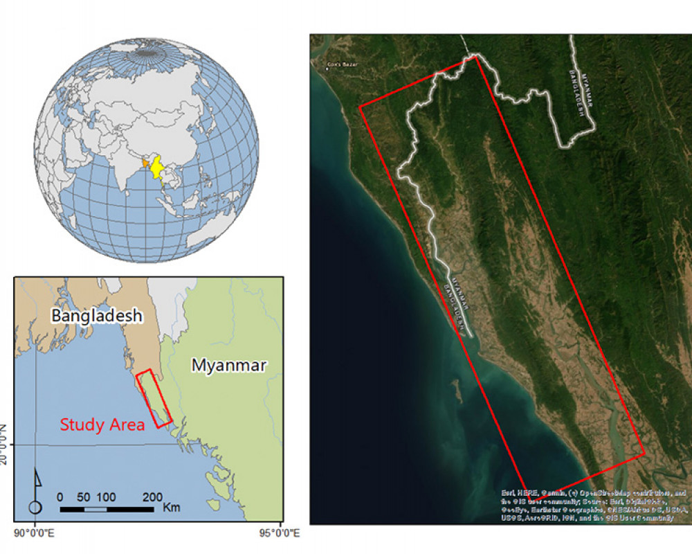
Figure 1: Location of Rohingya settlements that were subject to arson (© DLR)
Challenges
From a remote sensing point of view, the case of the Rohingya displacement is quite challenging. For optical imagery from space, cloud-free acquisitions are required. Yet, the displacement took place in the middle of the rainy season, with thick and high clouds largely obscuring the view. While other sensors, like Radar can penetrate clouds, optical imagery relies on sunlight and on a clear view from above. Radar sensors themselves proved unsuitable because of large trees within the settlements that disperse and disturb the signal before it reaches the houses.
An additional challenge were the sizes of the settlements. Considering that the size of one pixel of the most commonly used freely available optical satellites are 20 m (Sentinel-2) or 30 m (Landsat-8), a settlement needs to have a certain size to be clearly detected. With some of the settlements only consisting of a couple of houses, this limits the use of many sensors.
Furthermore, the potential time of burning was narrowed down by Human Rights Watch to be between the 25 August and 02 September. This left only eight days of potentially suitable satellite data acquisitions.
With regard to rising numbers of upcoming high-resolution satellites (e.g. micro satellites), the situation of data provision will even improve in the future.
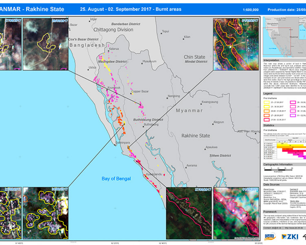
In the end it was a combination of different sensors, i.e. a medium-resolution sensor of 20 m (Sentinel-2) and a high-resolution sensor of 5 m (Planet) that proved suitable to detect the destruction of settlements and to limit their time of burning down to a few potential days. Planet data was available for four dates and Sentinel-2 data for one date, all of the data still largely covered by clouds. The data was pre-processed and cloud masked until only cloud-free areas covering the affected settlements were left. The data was then evaluated by experts for changes in the settlements (e.g. the disappearance of houses, the observance of ashes or smoke plumes). Other methods, like semi-automatic or deep-learning approaches were also tested but were not successful due to the patchy and fragmented data base. Thus, each settlement was analysed for the availability of clear observances and it was attributed with the burning information, if available. This information was provided to Human Rights Watch to support witness reports, to prove certain activities and to follow the strategy of the displacement (Figure 2).
Figure 2: Location and time of burning of the Rohingya settlements (© DLR)
Results
The time of burning could be narrowed down by more than two thirds of the overall 2,477 provided settlements. For some of the settlements, the burning could be pinpointed to have happened between 1-2 days or even to the exact day. For some settlements, the potential time of burning remains more vague or can only be stated to have happened before a certain day. Some of the settlements did not show any sign of burning at all. This information is still valuable for Human Rights Watch since it indicates that the arson must have taken place on a later date after the last satellite imagery observed within this study. The overall picture reveals that there is a clear burning structure for the whole study area. The fires started to take place in the centre area of the area and then extended to the North and slightly to the South, while in the end, the last settlements in the South were subject to burning activities. This pattern of burning indicates the movement and the displacement activities of the responsible delinquents, which can support the future activities of Human Rights Watch.
Outlook
This small insight into the case study shows that the use of satellite data and the setup of a user adapted workflow can provide information for large area humanitarian crises. With regard to rising numbers of upcoming high-resolution satellites (e.g. micro satellites), the situation of data provision will even improve in the future. This might lead to even more precise information for humanitarian actors, like Human Rights Watch. Similar insights on the displacement of populations would also be of use to peace operations monitoring the impact of violent incidents in their areas of operation. Here, there is room for further partnerships to be explored and to harness cutting-edge technologies in the service of peace.
Download article
IMAGES
- Author | Anne Schneibel priv.
- Figure 1 | © DLR
- Figure 2 | © DLR
REFERENCES
- Habib, M., Jubb, C., Ahmad, S., Rahman, M. and Pallard, H. (2018): “Forced Migration of Rohingya: The Untold Experience”, 1st edition Ontario International Development Agency Ottawa, Canada.
- Human Rights Watch News (2021): https://www.hrw.org/news/2021/06/07/bangladeshs-unplanned-relocation-rohingya-refugees-bhasan-char-island-risky), last access: 06 July 2021.
- Human Rights Watch Rohingya information: https://www.hrw.org/tag/rohingya, last access: 06 July 2021.
- IIMM | (un.org). Independent Investigative Mechanism for Myanmar (https://iimm.un.org/), last access: 06 July 2021.
- Martin, Anne-Sophie (2018): “Satellite Data as Evidences Before the Mechanisms of International Courts” in Post 2030-Agenda and the Role of Space. Springer, Cham, 2018. 97-106.
- Roscini, Marco (2016): “Digital Evidence as a Means of Proof before the International Court of Justice “, Journal of Conflicts and Security Law, Vol. 21, Issue 3, pp. 541–554
- UNHCR. https://www.unhcr.org/rohingya-emergency.html, last access: 06 July 2021.
- UN News 2021: UN teams assisting tens of thousands of refugees, after massive fire rips through camp in Bangladesh | | UN News
ACKNOWLEDGMENTS
Sentinel-2 data was provided with courtesy of European Space Agency. Planet imagery was provided by DLR (RESA – RESA, BMWi grant 50 EE 1612). HRW provided the initial satellite base damage assessment in the framework of the Data4Human project. Special thanks to Josh Lyons for the collaboration and expert advice.